10. Tracks, map and sharing
Every run you record is a track: the line you drove, plus the pins for the start, each control you marked, and the end.
10.1 Saving
Settings ▸ Tracks & roadbooks ▸ Auto save tracks (default: on). With it on, stopping a run saves without asking: the stop dialog offers a plain Stop, and that one button saves. With it off, the dialog gains a second button, Stop & Save Track, and once you have a few tracks saved the app offers to turn auto-save on for you. On a roadbook's final control the same dialog reads Finish?, with Finish and Finish & Save Track.
A quick restart always saves the run it ends, whatever this setting says; with auto-save off, its confirmation tells you so.
New tracks are stored with no title. The app then looks up the start point and fills in a place name for you. Until it does, the list shows the date plus a prompt to name it, and each row also offers a description.
10.2 The map
Swipe left from the dashboard.
| Icon | Control | What it does |
|---|---|---|
| Folded map | Map type | Standard, satellite or hybrid |
| Location arrow | Follow | Keep the map centred on your movement. The arrow fills while it is on |
| Diagonal arrows | Zoom out | Fit the whole route on screen |
| Square with an up arrow | Share track | Render a share image of the route |
| List | Show saved tracks | Open the track list |
Two things it will tell you rather than do: the saved-track list does not open mid-run, and there is nothing to share before anything is recorded.
10.3 The share image
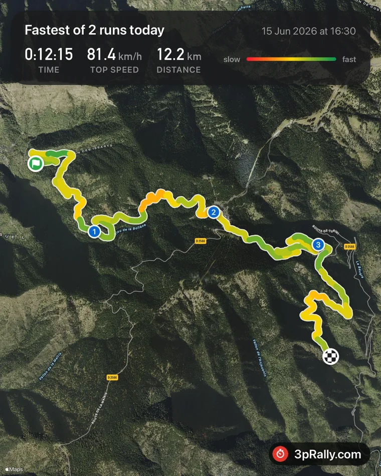
Share track renders a map card of your route with the headline figures, distance, time and average speed, and hands it to the iOS share sheet. You see a preview first.
On an ordinary card, time reads in minutes, as 40 min, or 2:05 h past the hour, with the unit in the same small type the distance and the speed use. A Special Stage card shows the exact elapsed time instead, as 0:12:15, because that time is the result.
A Special Stage run shares as what it is, rather than as a generic outing, and the headline counts the runs on that course, not everything you did that day.
It needs a network connection for the map tiles, and says so if rendering fails.
10.4 The track list
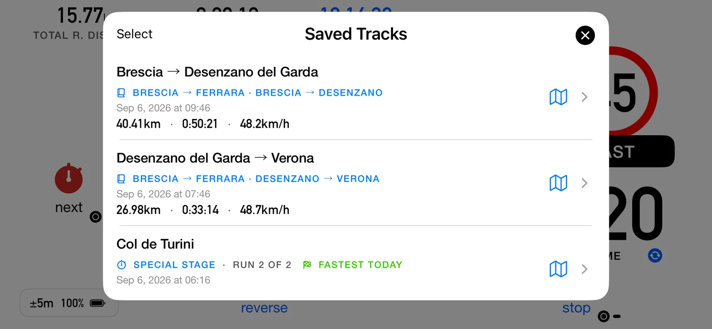
From the map's Show saved tracks.
| Action | How |
|---|---|
| Rename | Tap the title |
| Add a description | Tap the description line |
| Export | Tap the track to open its card, then Export, then GPX or KML |
| Delete one | Swipe, then Delete |
| Delete several | Select, then Delete |
Deleting confirms first. With iCloud sync on, the track stays in Recently Deleted for 30 days; without sync the deletion cannot be undone, and the confirmation says so.
Runs of the same course are grouped. Where you drove one course several times in a day, the list says which run of how many each track is, flags the fastest, and marks any run you discarded as not counted. It works out the grouping the same way the Stage screen does, so the two can never disagree: same day, starting within 500 m, and covering about the same distance (within 15% of the longer run).
Export formats
- GPX for most mapping and analysis tools.
- KML for Google Earth.
Both hold the track line and the waypoints, and the text inside them is always English regardless of your app language, because it is file content rather than interface.
The recap CSV
A roadbook run offers a third option in the same export sheet, alongside KML and GPX: Export results in CSV format. KML and GPX carry the coordinates; this one carries the outcome. It appears only on tracks that have a roadbook result to export, because a path format has nowhere honest to carry a scored table.
It writes a CSV file: one row per part, so you can sort, chart and compare two runs of the same course side by side. Open it in Numbers, Excel or any spreadsheet.
| Column | Holds |
|---|---|
roadbook, stage, segment |
which part of which book, numbered in driving order |
type, type_code |
the part's type: the word in your language, then a fixed code |
distance_km or distance_mi |
the distance the part was scored on |
distance_measured_km or _mi |
the distance the app measured |
distance_authored_km or _mi |
the distance the roadbook gives. Parts recorded before these two columns existed leave both empty |
time_s, ideal_time_s, delta_s |
seconds, always, so nothing has a clock format to misread |
avg_speed_kmh or _mph, target_speed_kmh or _mph |
held and asked-for pace |
max_exceeded, completed |
yes or no |
Three things are worth knowing before you build anything on top of it. The column headings
are always English, so a formula you write once keeps working after you change the app
language. The type word is translated and type_code beside it never is, so use
type_code when you compare files, and the readable word when you are just looking.
Numbers always use a dot and never group thousands, whatever your region shows on
screen, because a comma would collide with the commas separating the columns. Distances and
speeds follow your km or miles setting, which is why the heading names the unit.
10.5 iCloud
Settings ▸ Tracks & roadbooks ▸ Sync to iCloud keeps a copy of your saved tracks and your roadbooks in your own iCloud account. The section and the row are both named for the two, because on the Rally apps the one switch covers both.
Everything stays on this device, and the app works fully without iCloud.
Turning it on checks the account is usable first and explains any failure rather than silently doing nothing: not signed in, temporarily unavailable, restricted, or unreachable. If the check fails the switch flips back.
Once on, existing tracks and roadbooks are copied up, opening a list pulls the latest, and deletions become soft deletes that reach Recently Deleted on every device.
⚠️ iCloud is a backup and a convenience, not a competition tool. It never rewrites the route you are currently driving. See 5.14.
10.6 What a track holds
- The recorded line.
- Pins: the start, each control you marked, and the end. Tap a pin to see what it is, its number and the distance at that point, with its coordinates underneath. An unscored boundary drops no pin, which is what keeps your totals agreeing with the organiser's sheet. A control pin is titled with your own Segment name word, so it says the same thing the dashboard and the summary say.
- Your own landmarks. Zeroing the trip on a single-part roadbook drops a pin too, where you pressed. It is drawn differently from a control pin on purpose: a control is a place the organiser measured and scores you at, and this one claims nothing except that you zeroed there. It stays out of the summary and out of the exported results for the same reason. Useful when you are zeroing at landmarks off the paper and want to see afterwards where you actually did it.
- The title and description you gave it.
That is what makes a track useful afterwards. An argument about whether you really were at that junction is settled by opening the pin.